We are all travelers in the wilderness of this world, and the best we can find in our travels is an honest friend.
~Robert Louis Stevenson

Thursday, April 10, 2014

Day 5: A Gravel Road and a Styrofoam Container

Or:
Margaret Thatcher Never Tap Danced in a Charcoal Oven.

At this point on Thursday evening we are well past self amusement. We are sitting in the most adorable bed and breakfast in the Great Basin National Park.  The people are lovely and the log cabin is so cute. It feels like home, so much so that we have caught a little bit of the silly bug. Although to be fair, the Margaret Thatcher bit started much earlier.

We left Ely this morning and headed out towards Great Basin with our eyes on a stop at Ward. We bought supplies for the day at Ridley's (believe it or not!) grocery store.  There was an overwhelming abundance of canned goods, and we left with more processed foods than I'm sure mom has seen in a year!  We packed our cooler, and headed off!

We stopped first at Ward and saw their townsite and cemetery. Was this the actual first stop? Um, no. The first stop would have been when I hit the fan shortly after turning on to the dirt road. Our newly acquired styrofoam cooler was jumping all over the backseat. I opened our survival kit in hopes of finding duct tape and found a knife the size of a kindergartener (thank you BSHSW).  I ended up securing it with our sweatshirts and was quite proud of myself. That lasted until we drove in to a small ravine (emphasis on small).  So the rest of the trip, the cooler was seat buckled and creaking and groaning and squeaking with every movement of the vehicle.

Back to Ward: Unbelievably most of this town was moved across the valley to Taylor when the mine stopped producing.  Moving an entire town 10 miles before 1900 seems so hard!


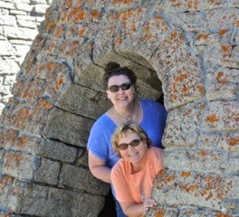
After the cemetery and townsite were the Charcoal Ovens.  These were amazing! Built by the "carboneri" (Italian worker), these provided the charcoal to run the mine at Ward and other surrounding mines.  So much timber was required to produce the charcoal needed to run the mines, that often the timber surrounding charcoal ovens was cleared in about a 35 miles radius.  There was an intricate 12 day process that was taken to create the charcoal.

The ovens have been well kept, and were fun to walk around in. The acoustics were amazing, so I did a little tap dance in each one. Flap, flap, flap, flap, cramp roll, paddle and roll...  It was gravel, and I had to dance around the cow pies. And I was wearing Chacos.  And my hair looked like a bouffant. I'm not sure why the bouffant mattered so much, but it added to the experience!


From Ward we headed to Great Basin National Park.  A big draw in this park is the Bristlecone Pine trees that are thousands of years old. We were hoping with the nice weather the road would be open, but it was still snowy. Next time! We did drive as far as possible and walk up the closed road quite a ways. These were the first actual trees we've seen (tree being something that is at least taller than our car!).


We were warned at the park about altitude sickness which has symptoms including: nausea, incoherent speech and headache. Wait, isn't that every day! Ha!


Afterwards we had a nice little picnic by Lehman Creek.


After driving briefly in to Utah, we are back in Nevada at Hidden Canyon Ranch for the night.


Tomorrow, a little less conversation, a little more driving…onward to Vegas!


Wednesday, April 9, 2014

Day 4: This is what we came for!

Today we took full advantage of our 4WD and had the high adventure we were after. After finding some really great coffee at a local flower shop, we headed back west on highway 50 in search of real ghost towns. We turned south on…well, we don't really know which road! The map we were working off was…fluid, at best.  :)  Basically, we turned south and headed in to the mountains.  Again, we spent the day driving through mountain passes!


The first "town" we were looking for was Hamilton. It was another community built to support silver mining in 1868.  The road was gravel and dirt, and had deep ruts in places, but was dry, except for some snow melt. The going was slow and very bumpy!  One of us was dreadfully carsick, and the other was killing it with amazing driving. :)

After several miles we were sort of stumped with our whereabouts. The roads (can you call them roads?) in front of us didn't resemble the map at all.  As we came around one corner, I happened to look back behind and saw a grave marker. Aha! We had stumbled upon the Hamilton Cemetery.


As with all old cemeteries, this one held us in a bit of reverence.   Most of the graves were overgrown, or broken, and there were very few that were marked. We poked about, inferring the stories that lay before us, and tracking a few of the families.  At 8,000 feet, the views were amazing; white grave markers, red dogwoods and white capped mountains.  At the top of this small peak, we could see nothing for miles.


Knowing we were close, we zoomed (you know, at less than 15mph) down the hill a ways to find what was left of Hamilton.  Nobody lives here anymore and we were free to walk around, explore and take pictures.


After Hamilton, we followed a park service type sign to Belmont Mine. This wasn't in our book, but I had seen it online, and it looked amazing. Getting there was…trying.  We were way past the road less traveled.  :)


Honestly, when we came around the corner (not the first corner…) we were blown away. That this mill was tucked away in the hills, unseen, was amazing.


This felt like a ghost town -- abandoned, ruined, and lots of weird noises as the wind blew.  This was what we had been looking for. Belmont was hard to find, and we reveled in standing in a place that few have stood in that last hundred years or so.  In its day, it served as the mill for the Babylon Mine, and still has part of the tram standing.

 Of course, all of these pictures were shot from outside the structures, complying with our safety first motto...  Adventure on!


We spent our entire day about an hour from our hotel, but we saw absolutely no one. We were nestled between the Pogonip Ridge and the White Pine Range, between 7,000-8,000 feet in elevation.  There were roughly seven other mines on our map in the area, but none were apparent to the naked eye. Almost 150 years later, the land has not changed that much! It was such a beautiful area, but so hard to imagine how people found veins to mine, how they traveled here and ultimately lived and worked.

Tomorrow is National Park day -- Great Basin here we come!


Tuesday, April 8, 2014

Day 3: The Loneliest Road in America

Today we found that the moniker for Route 50 is so true. But that comes later in the day!

We started the day just outside of Fallon at Grimes Point looking at petroglyphs.  Yesterday we spent the day living and breathing the Comstock Lode, and going back so far in time to petroglyphs was fun! There weren't real recognizable images, but it was a fun discovery none the less.


After Grimes Point, we headed just around the corner to Picnic Cave.  The full trail included hikes to Hidden Cave which is more famous, but it was SO hot, and at around 6,000 feet, so hiking for me in particular wasn't super conducive.  I packed 3 bottles of nail polish, but not my inhaler…  Nice.  I was a little bummed not to see the famous "lizard" petroglyph, but we wound back down a different trail to the car. And there it was!! This was the most recognizable petroglyph, and very easy to see (meaning it was one of the newer ones).


Next stop was Sand Springs Station and Sand Mountain. Oh, and sunburn capital of Spring Break. At this point it's unclear what is sunburn and what is heat rash…  I suppose given a few more hours it will be clear! Sand Spring Station was a Pony Express Station. Of course we are saturated in Pony Express information, and we won't bore you with all of it, but here's a quick fact I thought was interesting: horses were changed out every 12-15 miles, but riders were changed out every 75-100 miles. In the photo below, note the preferred rider!


The terrain here was…hot! Actually, that's not what I was going to say. :)  I'm just sitting here watching my skin get redder and redder!  The terrain was actually very diversified.  There was quite a bit of sand, which turned in places to salt flats.


Sand Mountain, which was in the back is this amazing 2 mile long, 600 foot tall dune, right in the middle of…nowhere!  The sand is from a dried up lake (you know, 4,000 years ago), which blows around and because of the way the wind blows and the surrounding mountains, drops right where the dune is. That is an incredibly simplified explanation, but it's close enough! The other cool thing is that it is a "singing dune". We didn't experience this phenomena, but evidently when the wind blows, the sand "sings" as it blows across the dune.


This is where the Loneliest Road comes in to play.  Driving east on 50, we saw…lots of nothing. Amazing mountains and valleys, and not a lot of people. We pulled off the road whenever there was a historical marker, and we went down random roads in search of adventure.  One of these adventures was in search of the Fairview Fault Lines. I know, who seeks out a fault line? This took us on to Naval Air Station land, across a very washed out road. I ended up driving for a large portion of this stretch. You know, driving, instead of yakking… We didn't actually get far enough to get up to Fairview Peak to see the fault, but this was high adventure -- 4 wheel drive, cows, weird military stuff…  The stuff that  Spring Breaks are made of!


In Austin, we stopped at the International Hotel. It was the "free bathroom" sign that caught my attention. I had by-passed an outhouse earlier in the trek. You know, because I have an irrational fear of something jumping out of those things. Not kidding.  The International Hotel was actually built in Virginia City in 1859 and moved to Austin a few years later. It isn't a hotel anymore, but has the best bathroom for about 100 miles, and a lovely lady who bakes a mean cookie.


After Austin there was…wildlife? I mean there was almost nothing.  The land changed over and over. We went through 9 mountain passes, made elevation changes totaling about 3,000 feet and saw a lot of animals that we didn't expect to! Lots of cows, donkeys, lizards, jackrabbits, deer, and 3 extremely large elk that were too close to the road for us! What we didn't see a lot of was…water.  Nine mountain passes, means there were quite a few valleys, but no rivers or lakes. Even driving through River Valley ( BSHSW -- we are not making that up!), there was not a river in sight.

It took the entire day, but we finally rolled in to Ely.  We are filthy, and exhausted, and loving every second of this really weird vacation we're on!!


Monday, April 7, 2014

Day 2: The Comstock Lode

We cannot believe it's only Monday! In fact, we had the best vacation experience today -- at a State Park, we couldn't come up with the date to write on our entrance fee slip, and had to really think to come up with the day of the week. If you don't write it on the board in the morning, the date just sort of slips away!  :)

We headed out of Tahoe today, north before we headed east on the Loneliest Road in America. No, that's not my snarky sense of humor -- that's what it's really called! Today was all about the Comstock Lode.  We hit Carson City first, just on a drive-through, and headed up in to the hills to Gold Canyon.  Here we were struck by the fact that mining isn't a history lesson, but something that is ongoing. We drove past a sign announcing upcoming mining blasts, and in several places were able to see 21st century equipment side by side with ruins.  The Comstock Lode may be part of history, but the Comstock Project is happening right now!


Virginia City was the destination this afternoon, and it didn't disappoint!  Back in the day, there were upwards of 15,000 residents working and living in the mining community.  The main drag had original storefronts and saloons, and was a fun walk through the past.  We opted not to eat at Bucket of Blood Saloon (shocker!), but had amazing waffle concoctions at the Roaster.  Virginia City, is unbelievably, the birth place of Mark Twain. I know, sounds wrong, but it was the first city where he used his pen name, writing for the Territorial Enterprise.


From Virginia City, we headed back down the hills, to Carson River, where we….took the road less traveled.  What's a road trip without a gravel road?  This road was part of the Pony Express Trail -- man, I love that we were driving on the same path that riders rode years before! The road wound through deserted and active ranches, hugging tight to the river.  At the time, I thought that the RBC I spotted (that's a really big cow) was the find of the day. Really -- it was huge!  But then…far off in the distance we saw some dust rising up indicating a vehicle was coming. And as it got closer (don't presume that we were actually cutting the distance) we both were stymied by what we are seeing. One thing that was true was that this thing was hauling -- moving upwards of 60 mph.  And the other thing that was true was that it was a tank!  We had stumbled upon an automative test area.  And that's all that we are cleared to say at this time.  Ha!


Then, all of a sudden, the road turned back to pavement, and up on the hill was Fort Churchill. Seeing it after this long road felt like a major discovery!  Fort Churchill was established in 1860 after an "incident" with the American Indians.  The buildings were all created using bricks and stand in various states of ruin. The awesome thing was that for the most part, we were the only ones there.  It was sunny and 70 degrees and we had fun just poking in and out of the buildings and taking amazing pictures.


We are now snuggled in to an amazing room for where we are -- Fallon.  Tomorrow we anticipate more sunshine and discovery!

Sunday, April 6, 2014

Seattle to Reno to Tahoe!

Our adventure is barely 12 hours old, but already we have done so much! The real adventure came at around 7:30 (yes, AM) when we heard our names on the airport loudspeaker. Huh. How many planes are ready to leave early? You know, ready except for the two missing passengers. Yikes!  So after a quick morning jog, we boarded what is the smallest plane I have flown in outside of Alaska. I mean bigger than a Cessna or something, but seemed so small to be flying out of SeaTac. Needless to say, we were wedged in like sardines.  Thank you, thank you, thank you that our flight was short!


Arriving upon Reno is when our typical Spring Break adventure began.  We have flown in to Atlanta twice, and each time, we have gone through multiple cars before getting one that was just right.  I have many "selfies" waiting with our luggage in Atlanta while mom exchanged car after car. In Reno, we got to our car -- a giant Ford Explorer. Four wheel drive, roomy, clean…and then we started the car.  And the "check engine oil" light came on.  

ACM Break -- The Band Perry is singing….

Anyway, there was a lot of laughter as we began the process of exchanging cars in yet another airport. It's looking like a trend at this point!


From Reno, we drove up through the mountains and in to Tahoe where we are staying just across the state line in California.  Lake Tahoe is everything we had heard -- huge, clear and beautiful! We had amazing pizza for dinner -- yes pizza that rivaled Fultanos, Lahaina Pizza Co., and whatever that place in Bermuda was.  


We have mapped out tomorrow and are ready to forget what a normal Monday would hold and explore some ghost towns!!